California: the snowpack has been insufficient
Drought is increasingly affecting California, a state that seasonal storms have tended to avoid in recent weeks... This year, many regions are expected to record the driest February since the introduction of meteorological statistics. Indeed, California has not recorded any major event of rain or snow in the mountains since 26 December, and drought conditions, which prevailed in the state from 2011 to 2017, have reappeared on the maps of the National Oceanic and Atmospheric Administration (NOAA).
The current situation was not announced in the forecasts, as the onset of winter suggested an abundant snowpack and an easy transition to spring requirements, as was the case last winter. But now, it is clear that rainfall and snow have moved north since the beginning of 2020, with temperatures above average and increasingly evident drought conditions.
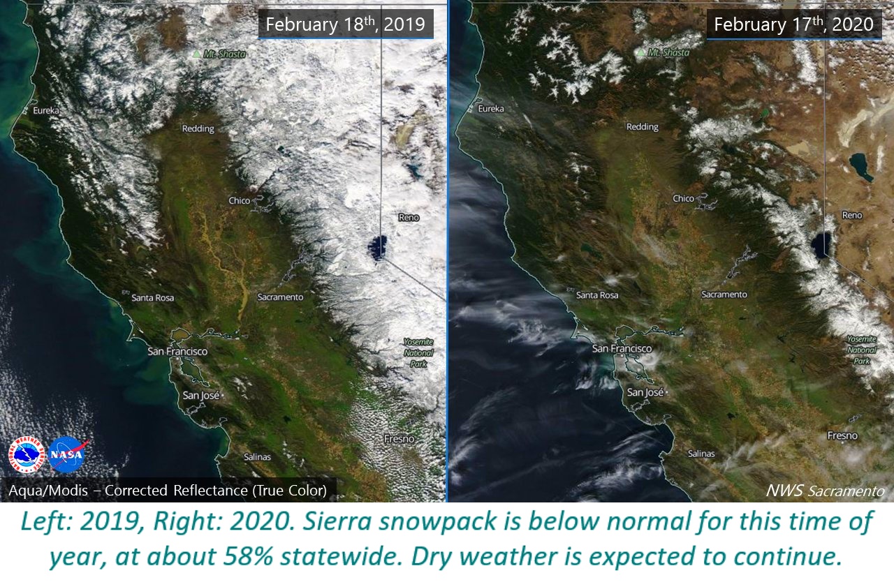 As of 20 February, the statewide snowpack only amounted to 52% of the average for this time of year, down sharply from the 92% recorded on 1 January. As Californian agriculture awaits the next big storm, the rainfall deficit increases, and drought and fire risks worsen, during what is usually one of the wettest periods of the year.
Most of California received less than one quarter of the usual average rainfall in January and February. The few rainy episodes in the first two months of the year were rated as light to moderate. According to the US press, February in California was extremely dry, to the point that the light rainfall recorded could fall to an all-time low. In some places, including San Francisco, Sacramento and the northern Sierra Nevada, February rainfall was not measurable.
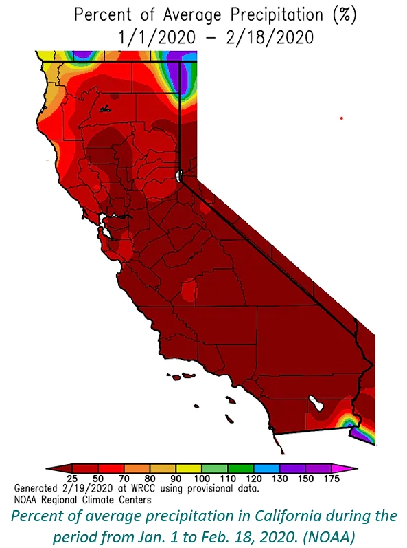 The situation is slightly less grim in the South of the state (San Diego and Los Angeles) where the storms of November and December helped to offset the rainfall deficit of early 2020.
But in parts of northern California, as well as in the Sierra Nevada, which is one of the state's natural reservoirs for irrigation, the situation is delicate. These regions have received less than half of the precipitation forecast of the previous water year (1 October – 30 September), and the lack of rainfall from 1 October to 25 November 2019 clearly marked the start of the dry season.
The situation is slightly less grim in the South of the state (San Diego and Los Angeles) where the storms of November and December helped to offset the rainfall deficit of early 2020.
But in parts of northern California, as well as in the Sierra Nevada, which is one of the state's natural reservoirs for irrigation, the situation is delicate. These regions have received less than half of the precipitation forecast of the previous water year (1 October – 30 September), and the lack of rainfall from 1 October to 25 November 2019 clearly marked the start of the dry season.
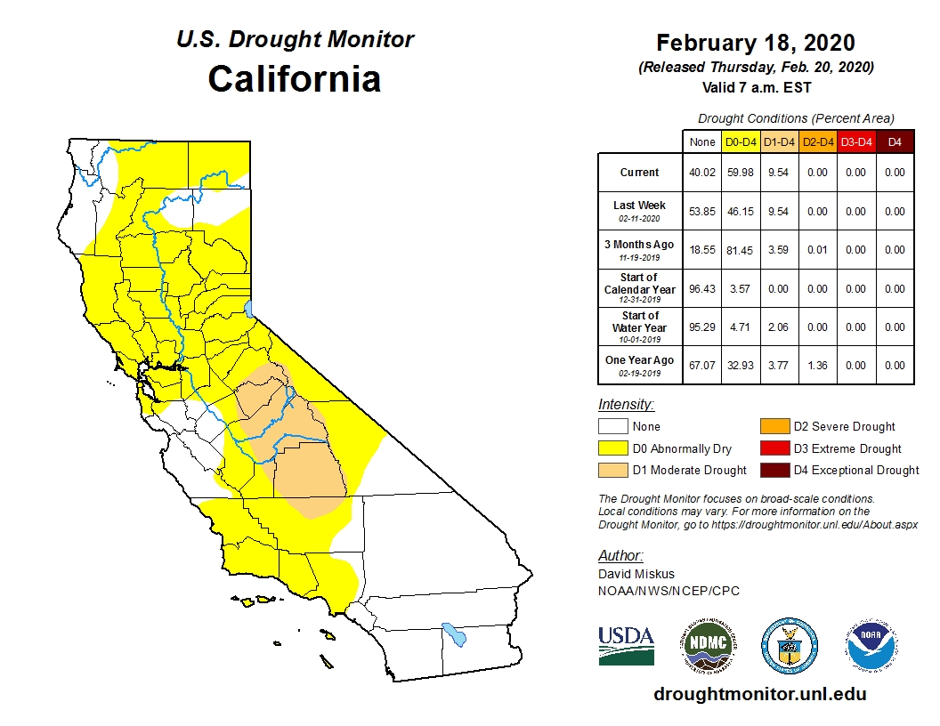
Drought conditions in California as of Feb. 18, 2020. (U.S. Drought Monitor)
According to data from the US Drought Monitor, about 60% of California’s territory was considered abnormally dry or in a situation of moderate drought as of 18 February.
Richard Tinker, drought expert at the NOAA Climate Prediction Center, believes that a possible worsening of rainfall deficits this winter is unlikely to intensify the drought in the short term: " What we certainly can say is that — if the wet season winds down and there is deficient snowpack and some sort of precipitation deficit, drought will only at best remain unchanged until the next wet season, which would mean through the summer and into the fall."
Europe: unexpectedly mild temperatures
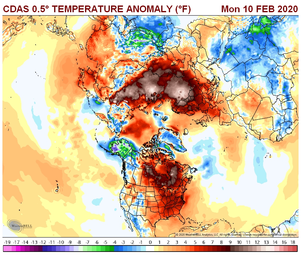
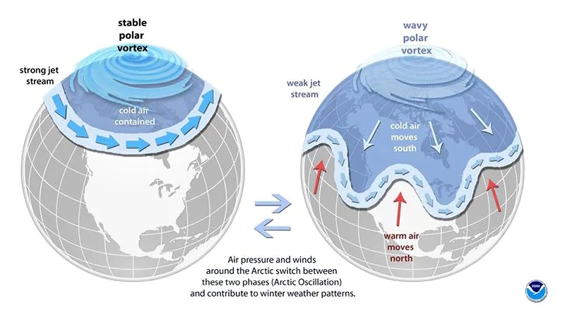
Exceptional weather conditions in the Arctic have kept the consequences of winter at bay in most of the United States and Europe, creating the warmest winter conditions ever recorded in these regions. This phenomenon is linked to a meteorological pattern known as the Arctic Oscillation (AO) which prevents dry icy air from heading south. Europe had its hottest January ever, and the United States had its hottest winter ever, with exceptional temperatures in December (the sixth hottest) and January (the fifth hottest ever recorded).
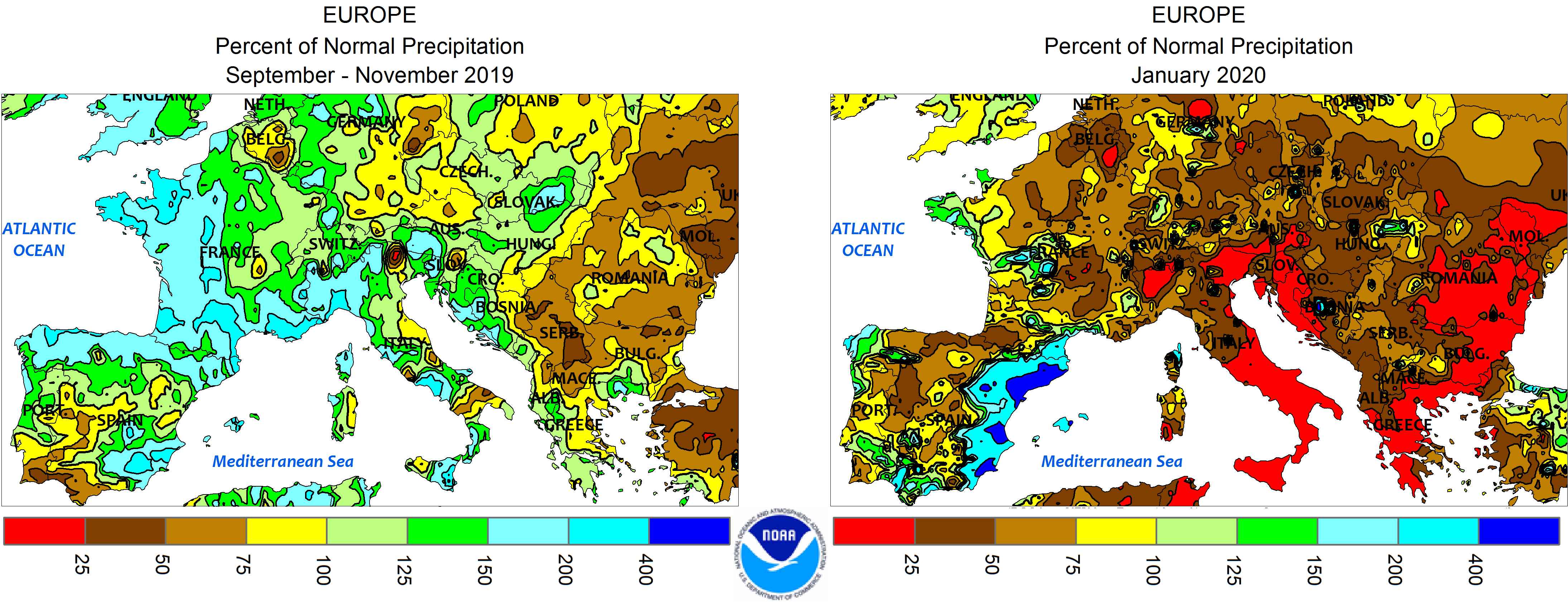
These abnormally mild conditions in Europe were particularly felt in the East of the region, from the North of Turkey and Greece to the North of Romania, less markedly in other processing tomato growing regions (northern and southern Italy, France). However, winter temperatures were in line with seasonal norms in Portugal and Spain.
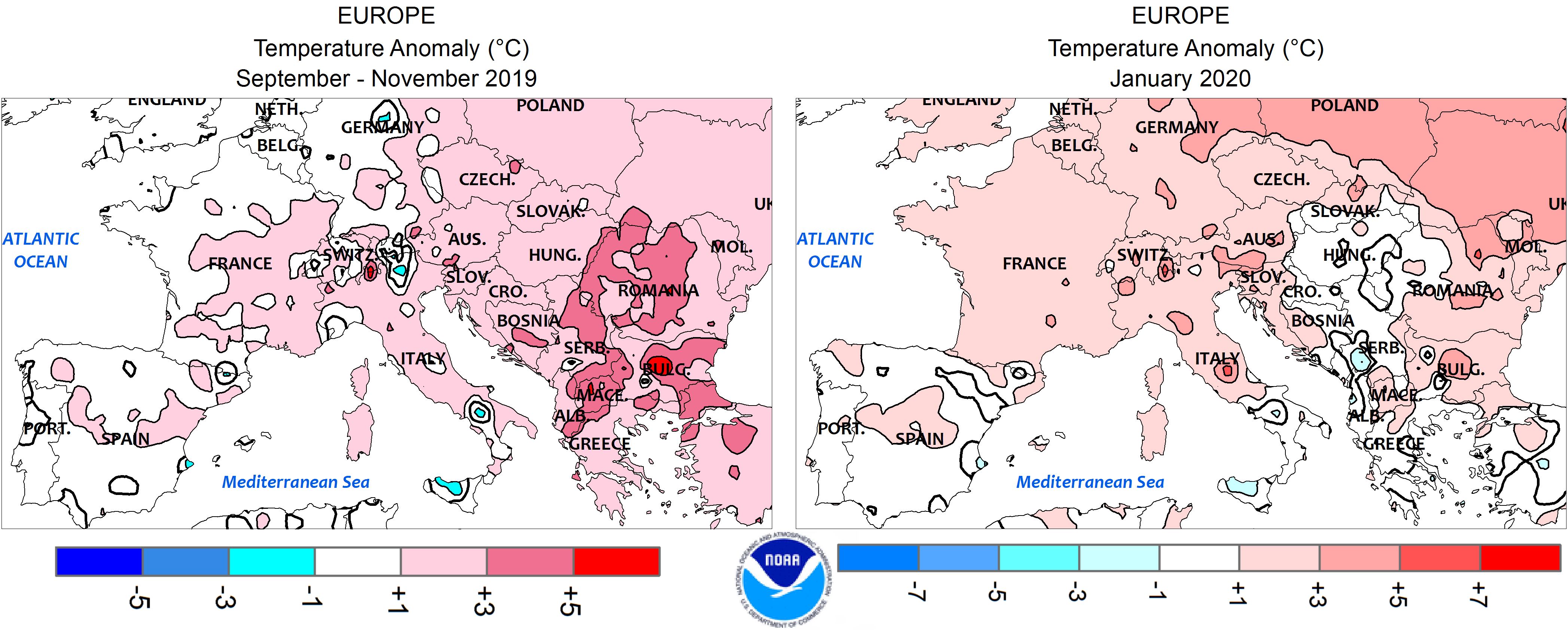
Over the same period, rainfall slightly exceeded the usual averages in France’s tomato growing regions and occasionally in Italy and Greece. The first month of 2020, on the other hand, was exceptionally dry, particularly in southern Italy and Greece.
Some complementary data
Polar view of the situation (temperature differences compared to normal over the past 60 days) on Monday 10 February 2020. (USA bottom center, Europe right, Russia and China top).
Source: washingtonpost.com, WeatherBell, NOAA